South Fork Old Stage Road
Just across the river by the campground
is the South Fork Old Stage Road – still used, and I'm sure it's as
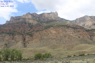
bumpy as it ever was. It is a spectacular drive through Shoshone
Canyon, which is a gorge formed by erosion through Rattlesnake
Mountain. Rattlesnake Mountain was born about 66 million years ago,
about the same time dinosaurs became extinct. The uplift from the
drove rocks vertically about 2,000 feet along the fault line. The
rocks exposed range from 230 million years to 2 billion years, the
age of the granite at the dam.
We were told Big Horn Sheep were often
seen at the end of this dirt and gravel road, which was a Big Horn
Sheep Sanctuary so we packed a lunch and headed out. The road wound
around behind the mountains you see in some of the campground photos
and continued through some beautiful and wild country. We saw a big
male pronghorn soaking up the sun – it seems that the males and
females stay in separate herds this time of year and the older males
tend to be more solitary. Fairly typical, don't you think?
We came upon Castle Rock and found from
the
nearby sign that John Colter passed this landmark in 1807 while
looking for Indians with whom he could trade. He was also searching
for salt caves, which were reputedly located near the headwaters of
this stream, the “stinking waters” later named the Shoshone
River. Colter was the first recorded white man to visit the Upper
Wind River, Jackson's Hole, and the Yellowstone area. I can't imagine
being here all alone with only a horse, maybe a couple of pack
animals, and some provisions – it gets really dark out here not to
mention cold and windy.
Attached to the sign about Castle Rock
was a nesting box and there was a pair of mountain bluebirds waiting
patiently for us to drive on before feeding their little ones. We
didn't move on, and their nestlings were protesting loudly so the
pair took turns going to the mouth of the nest to give their
youngsters fat, orange grasshoppers. Presumably they enjoyed them
more than I would have...
As we drove along, we saw what first
appeared to be a pile of tree limbs that had collected in the stream,
but after closer inspection, decided it
must be a beaver lodge. We
didn't see a beaver to confirm our thoughts, though.
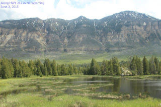
The road wound through some amazing
territory – some late-melting snow-capped mountain tops causing
waterfalls, rushing mountain streams threatening to overflow the
banks, and ranches an hour from anywhere. Mailbox houses are common
out here, giving a hint at the weather in the winter. Cody gets only
29 inches of snowfall annually, but up here there is considerably
more. One spot had several mailboxes in what looked like a shelter
for kids catching a school bus.
We're not in Florida any more.
In the pasture of one of the ranches we
came across a large herd of elk cows, feasting on the lush grass. We
dallied there for a while then headed out again. We came upon a
mudslide over the dirt road not far beyond the elk herd, so backed up
to a spot wide enough to turn around and headed back to camp. In
spite of not seeing any big horn sheep, we had a great day.
From Camp to Yellowstone to Chief
Joseph
Highway to Camp
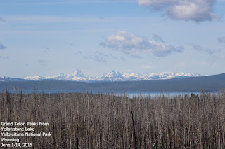
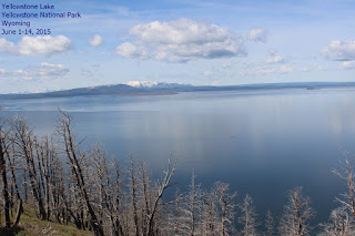
The campground is located on South Fork
Road and goes through the Shoshone National Forest, then into
Yellowstone National Park. We drove this road several times and one
day spent about ten hours driving the northeast loop in Yellowstone
then over Chief Joseph Highway, and back through Cody to Camp. We
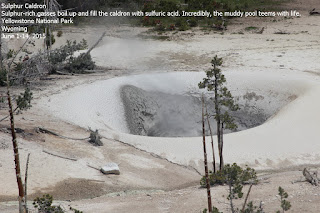
saw all sorts of beautiful scenery, wildflowers, animals, thermal
features in which grow a wealth of microbes, and several different
micro climates. I'm still overwhelmed with all we saw and learned,
there is so very much and it is all so
different from anything we've
seen before. I'm not even going to try to describe or explain. If
you're interested, a great place to start is the paperback
“Yellowstone: The Official Guide to Touring the World's First
National Park” published by Yellowstone Association. It has
beautiful photos, and gives descriptions of each of the main roads as
well as information about what you will see. It is a must for anyone
who hasn't been to Yellowstone.
Chief Joseph Highway
After leaving Yellowstone, we drove
Chief
Joseph Highway back to Cody. The route was amazing – going
from craggy mountains to the plains in about an hour. We went from
near twilight to bright sunlight as we got high in the mountains,
then a storm as we descended again. Nine-and-a-half hours of
beautiful, eerie, harsh, and any other superlatives you can think of.
We're still marveling at the sights of the day. I'm glad I saw the
Grand Canyon first, because for my money, Yellowstone beats it hands
down.
Our next stop is Baker's Hole CG on the other side of Yellowstone, if we can get a spot. Keep your fingers crossed.











No comments:
Post a Comment